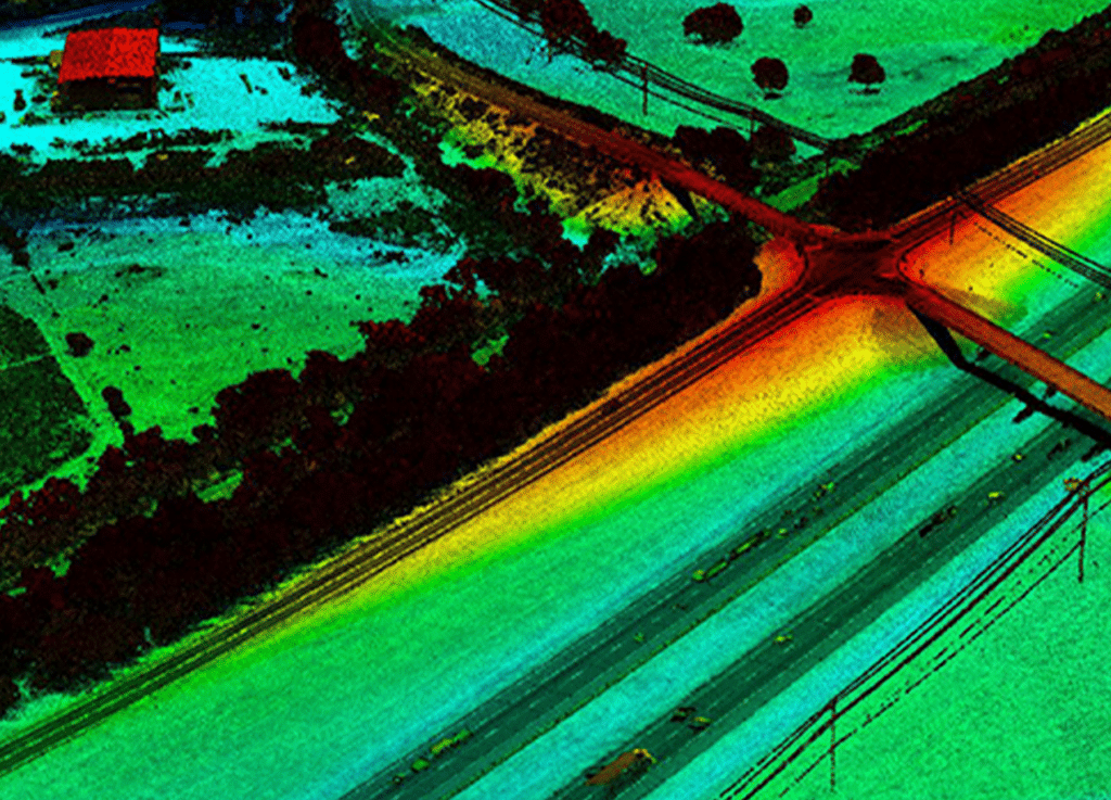
Transportation

Through our extensive experience in transportation, G&AI has established unparalleled field and technical procedures to ensure that the client receives the necessary and most accurate survey data possible to complete their design. With our background in engineering design surveying, G&AI has become familiar with the processes and data required by engineers to finalize project designs. Our diverse clientele includes TxDOT, NTTA, DART, Fort Worth Transportation Authority, Denton County Transportation Authority, DFW Airport, municipalities, and more. G&AI’s project portfolio encompasses a wide range of transportation projects, including, but not limited to, roadway, highway, transit, aviation, bicycle/pedestrian, transportation drainage, bridges, retaining walls, railroad, and more.

G&AI has been a prime contractor for the Texas Department of Transportation (TxDOT) in Tyler, Dallas, Fort Worth, and West Texas Districts and a reliable subcontractor for multiple firms on TxDOT projects since 1990.

IH-10

The project included professional survey and aerial mapping and LiDAR along IH 10, from the Colorado River to the Brazos River, in Colorado and Austin Counties. Helicopter LiDAR data was captured along the 31-mile transportation corridor at approximately 1000’ AGL.  G&AI processed, classified, and performed DTM feature extraction from the LiDAR point cloud. In addition to LiDAR, G&AI also captured 5cm GSD (ground sampling distance) digital imagery to produce Ortho imagery and to collect 2D planimetric for the project. This project was delivered on time and exceeded accuracy specifications.

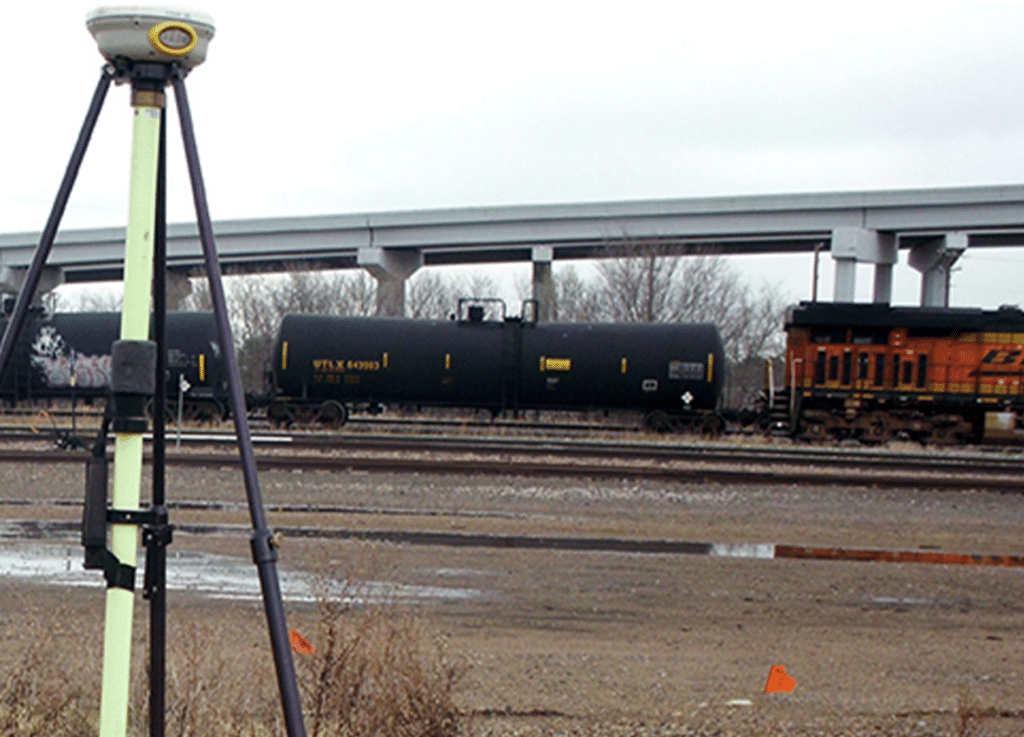
TexRail Design Build Project

G&AI was responsible for providing comprehensive subsurface utility engineering services and land surveying for the future light rail line from Sycamore School Road to DFW International Airport. Services included static GPS for the creation of a horizontal and vertical control network for the project, supplemental topographic/design surveying and the pulling of records and mapping of utilities. This new transit program will utilize both existing and new rail. G&AI provided cost estimates for the utility adjustments at street crossings and station locations. G&AI wrote the utility summary with possible impact to the project within the EIS. Phase II included the mapping of all utilities in the existing corridors, at street crossings and proposed rail stations.

Transfer Station and NE Police Station

G&AI was contracted by DART to perform surveying services associated with the design of the transfer station and DART’s NE police station. G&AI performed the deed research on the parent tract of land and adjoining properties. G&AI utilized existing DART control monuments and verified the three closest DWU benchmarks associated with utility plan sets. G&AI performed the boundary survey and the topographic mapping of the 6.859 acre site. G&AI located all improvements, utilities, driveways, LBJ access road, adjacent rail lines and existing facilities. G&AI furnished DART with the boundary survey, topographic survey, digital terrain model (DTM) with 1-foot contour lines and digital files created to DART’s CADD standards. After the design of the transfer station was approved by DART, G&AI was asked to provide the platting services for the facility. The platting was performed to City standards working closely with subdivision staff to ensure all requirements were met and to receive departmental approval.

Denton County Transportation Authority Transfer Stations

G&AI provided surveying services associated with the acquisition and design of proposed transfer stations on the new DCTA line. G&AI performed Project client-ship research on the properties to be acquired by DCTA and on the properties adjoining the proposed transfer station sites. G&AI also located and verified local benchmarks to provide the datum for existing utility lines and located FEMA benchmarks to provide the basis for the design of improvements within floodplain areas.  G&AI furnished DCTA with boundary surveys performed to the standards and specifications of a TSPS Category 1A survey. G&AI performed the topographic mapping of each property, locating improvements, utilities, adjoining streets and roadways, driveways, and existing rail lines. Once DCTA approved the design of the facilities, G&AI was asked to perform the platting services on the transfer station sites. G&AI coordinated with the City of Denton and the City of Lewisville to ensure their regulations and procedures were understood, and all of their platting criteria were met.

G&AI furnished DCTA with boundary surveys performed to the standards and specifications of a Texas Society of Professional Surveyors’ Category 1A survey. DCTA used these boundary surveys to acquire the property for their transfer stations. G&AI performed the topographic mapping of each property locating improvements, utilities, adjoining streets and roadways, driveways and existing rail lines. Once the design of the facilities was approved by DCTA, G&AI was asked to perform the platting services on the transfer station sites. G&AI prepared the plats, descriptions and certifications to each of the cities’ standards and showed any new utility easements required for the sites.

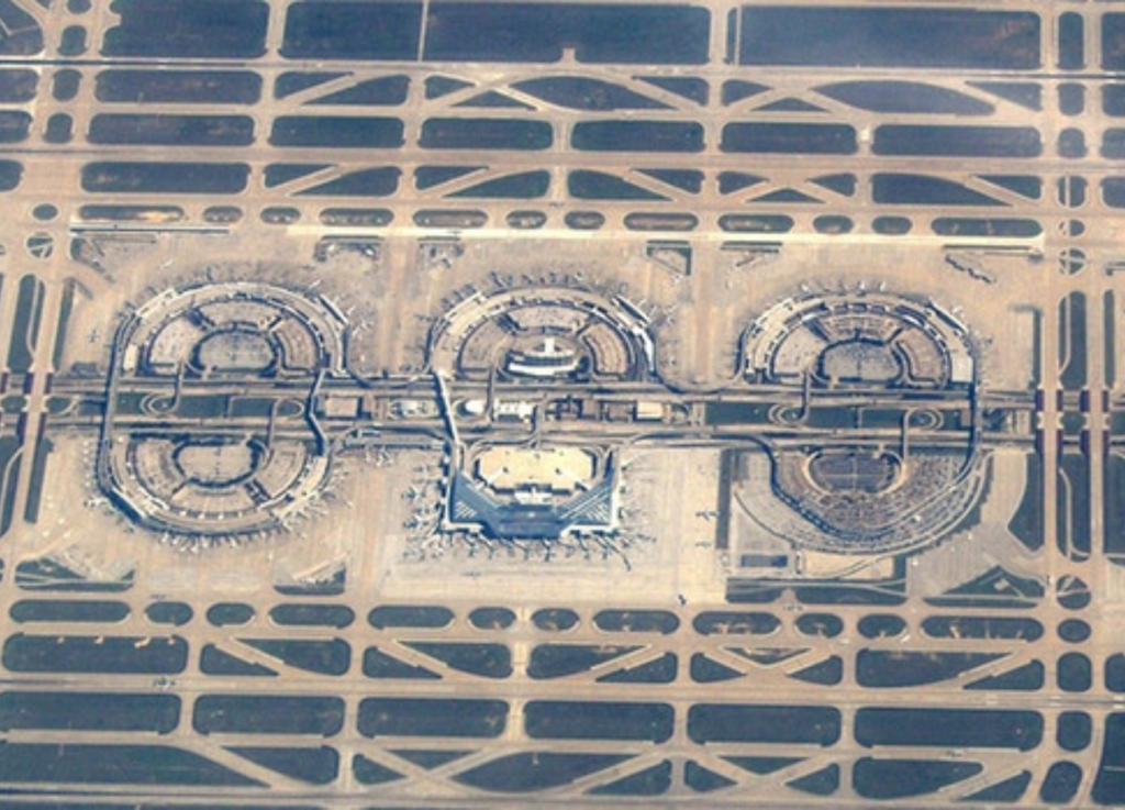
Terminal Development Program (TDP)

DFW Airport Planning Department set up this project to revitalize Terminals A, B, C, and E along with the entry ramps, parking garages and International Parkway. The project team consisted of 32 engineering and architectural firms. Gorrondona & Associates, Inc. (G&AI) was the only firm providing surveying services on the team. G&AI surveying services included mapping International Parkway and all the frontage roads, bridges and ramps; mapping all the existing features of the abandoned airport people mover (APM), bridges and ramps; mapping the access roads, ramps and connectors to Terminals A, B, C and E; mapping the lower level driveways, ramps, structures, utilities, baggage kiosks, and the facades of the parking garages and terminal walls for Terminals A, B, C and E. G&AI also mapped the roadways, parking lots, canopies, APM facilities and utilities for the design of expansions to the North Express Parking.

Our team is happy to answer your questions. Contact us and we’ll be in touch as soon as possible.

Scroll to Top