Terminal Development Program (TDP)
About the Project
CLIENT
DFW International Airport
LOCATION
DFW Airport, Texas
PROJECT TYPE
Boundary survey, Professional Land Survey, Topographic Survey
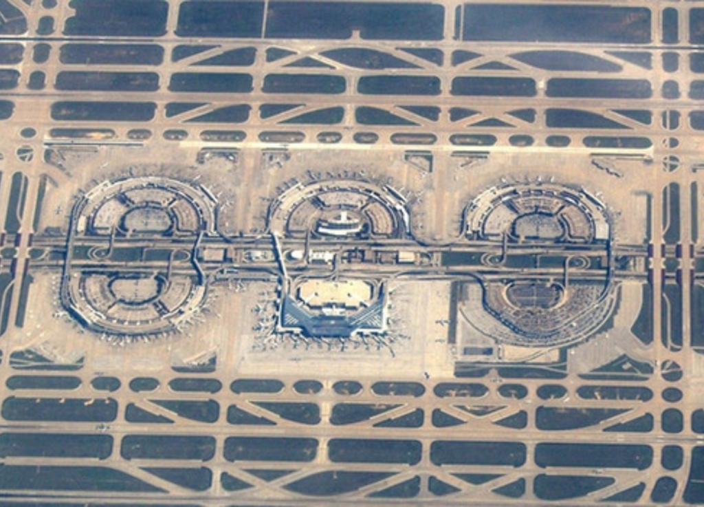
DFW Airport Planning Department set up this project to revitalize Terminals A, B, C, and E along with the entry ramps, parking garages and International Parkway. The project team consisted of 32 engineering and architectural firms. Gorrondona & Associates, Inc. (G&AI) was the only firm providing surveying services on the team. G&AI surveying services included mapping International Parkway and all the frontage roads, bridges and ramps; mapping all the existing features of the abandoned airport people mover (APM), bridges and ramps; mapping the access roads, ramps and connectors to Terminals A, B, C and E; mapping the lower level driveways, ramps, structures, utilities, baggage kiosks, and the facades of the parking garages and terminal walls for Terminals A, B, C and E. G&AI also mapped the roadways, parking lots, canopies, APM facilities and utilities for the design of expansions to the North Express Parking. G&AI furnished MicroStation drawing files, digital terrain models DTM with planimetrics and applicable 1-foot contour lines, ASCII point files with point numbers, x,y,z coordinates, codes and descriptors, field sketches, photographs and control point recovery sheets for the design of utilities, structures and new terminal connectors.
DFW Airport Planning Department set up this project to revitalize Terminals A, B, C, and E along with the entry ramps, parking garages and International Parkway. The project team consisted of 32 engineering and architectural firms. Gorrondona & Associates, Inc. (G&AI) was the only firm providing surveying services on the team. G&AI surveying services included mapping International Parkway and all the frontage roads, bridges and ramps; mapping all the existing features of the abandoned airport people mover (APM), bridges and ramps; mapping the access roads, ramps and connectors to Terminals A, B, C and E; mapping the lower level driveways, ramps, structures, utilities, baggage kiosks, and the facades of the parking garages and terminal walls for Terminals A, B, C and E. G&AI also mapped the roadways, parking lots, canopies, APM facilities and utilities for the design of expansions to the North Express Parking. G&AI furnished MicroStation drawing files, digital terrain models DTM with planimetrics and applicable 1-foot contour lines, ASCII point files with point numbers, x,y,z coordinates, codes and descriptors, field sketches, photographs and control point recovery sheets for the design of utilities, structures and new terminal connectors.
Our team is happy to answer your questions. Contact us and we’ll be in touch as soon as possible.