SL East Stiles Sub, SL Einstein, and SL East Stiles
About the Project
CLIENT
Oncor Electric Delivery
LOCATION
St. Lawrence, Texas
PROJECT TYPE
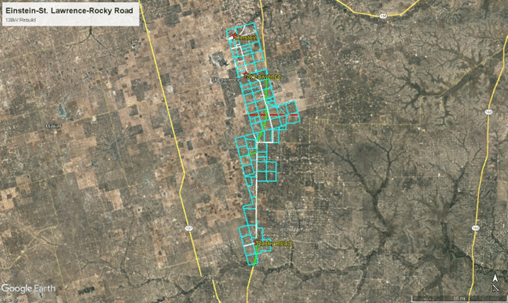
G&AI provided survey services for three transmission line rebuilds, totaling 24.7 miles, all part of the same line. The segments were SL East Stiles Sub – St. Lawrence Sub 138 kV Line (13 miles), SL Einstein- St. Lawrence 138 kV Line (4.6 miles), and SL East Stiles Rocky Road 138 kV Line (7.1 miles). Services included GPS control, ownership deed sketch, ROW survey, substation survey, crossing survey, overhead utility survey, design survey, easement sketch and descriptions, geotech survey, ROW staking, and construction structure staking. Utilizing RTK/GPS, G&AI established horizontal and vertical control, providing property boundary maps for Oncor’s proposed transmission right of way. G&AI located existing railroads, state and county roads. Overhead features were surveyed within 50 feet of the centerline. Supplementary topographic surveys addressed conflicts at proposed structure locations and major road crossings. Easement sketches and descriptions were provided for temporary construction and access easements. G&AI also staked soil boring locations, existing ROW edges for vegetation management, and proposed structures along the three transmission lines.
G&AI provided survey services for three transmission line rebuilds, totaling 24.7 miles, all part of the same line. The segments were SL East Stiles Sub – St. Lawrence Sub 138 kV Line (13 miles), SL Einstein- St. Lawrence 138 kV Line (4.6 miles), and SL East Stiles Rocky Road 138 kV Line (7.1 miles). Services included GPS control, ownership deed sketch, ROW survey, substation survey, crossing survey, overhead utility survey, design survey, easement sketch and descriptions, geotech survey, ROW staking, and construction structure staking. Utilizing RTK/GPS, G&AI established horizontal and vertical control, providing property boundary maps for Oncor’s proposed transmission right of way. G&AI located existing railroads, state and county roads. Overhead features were surveyed within 50 feet of the centerline. Supplementary topographic surveys addressed conflicts at proposed structure locations and major road crossings. Easement sketches and descriptions were provided for temporary construction and access easements. G&AI also staked soil boring locations, existing ROW edges for vegetation management, and proposed structures along the three transmission lines.
Our team is happy to answer your questions. Contact us and we’ll be in touch as soon as possible.