San Antonio River Authority Mission Reach Project
About the Project
CLIENT
San Antonio River Authority
LOCATION
San Antonio, Texas
PROJECT TYPE
Aerial Mapping, Horizontal & Vertical Control Surveying, Topographic Survey
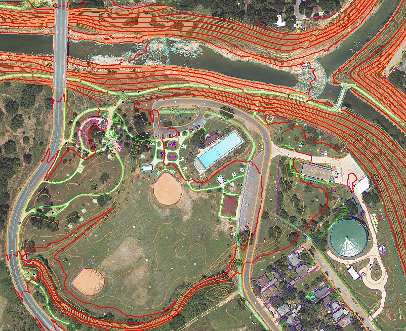
G&AI provided as-built aerial mapping services along approximately nine miles of the San Antonio River referred to as the “Mission Reach”. The area extended from downtown San Antonio to a point approximately one-half mile south of IH-410 on the south side of the City. GA&I acquired both color and color infrared aerial photography of the project area using a Zeiss/Intergraph DMC II digital sensor. This consisted of 170 overlapping exposures taken from a flight altitude of 2100’ AMT and included the acquisition of both airborne GPS and IMU data. Prior to taking the aerial photography, G&AI survey crews established targets at 54 strategic locations throughout the project area. The crews also acquired horizontal and vertical GPS ground control at each of the 54 points, all of which were visible on the imagery. G&AI then performed an analytical aerial triangulation adjustment of the targeted ground control.
G&AI provided as-built aerial mapping services to HDR Engineering Inc. along approximately nine miles of the San Antonio River referred to as the “Mission Reach”. The area extended from downtown San Antonio to a point approximately one-half mile south of IH-410 on the south side of the City. GA&I acquired both color and color infrared aerial photography of the project area using a Zeiss/Intergraph DMC II digital sensor. This consisted of 170 overlapping exposures taken from a flight altitude of 2100’ AMT and included the acquisition of both airborne GPS and IMU data. Prior to taking the aerial photography, G&AI survey crews established targets at 54 strategic locations throughout the project area. The crews also acquired horizontal and vertical GPS ground control at each of the 54 points, all of which were visible on the imagery. G&AI then performed an analytical aerial triangulation adjustment of the targeted ground control.
G&AI provided as-built aerial mapping services to HDR Engineering Inc. along approximately nine miles of the San Antonio River referred to as the “Mission Reach”. The area extended from downtown San Antonio to a point approximately one-half mile south of IH-410 on the south side of the City. GA&I acquired both color and color infrared aerial photography of the project area using a Zeiss/Intergraph DMC II digital sensor. This consisted of 170 overlapping exposures taken from a flight altitude of 2100’ AMT and included the acquisition of both airborne GPS and IMU data. Prior to taking the aerial photography, G&AI survey crews established targets at 54 strategic locations throughout the project area. The crews also acquired horizontal and vertical GPS ground control at each of the 54 points, all of which were visible on the imagery. G&AI then performed an analytical aerial triangulation adjustment of the targeted ground control.
Our team is happy to answer your questions. Contact us and we’ll be in touch as soon as possible.