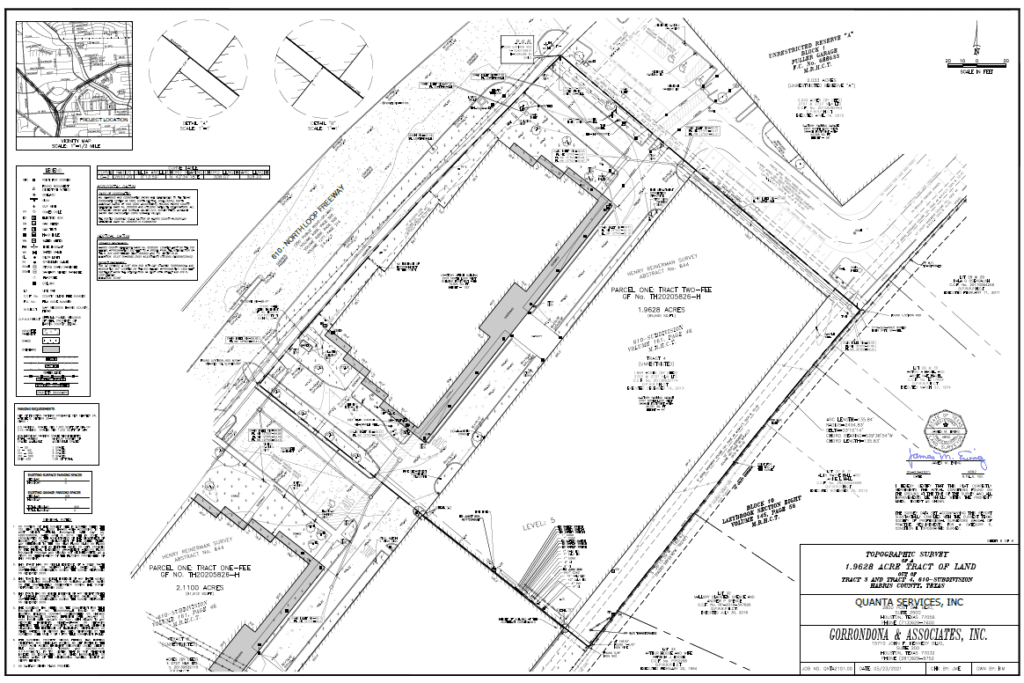
A 2.11 ACRES OF LAND BEING TRACTS 2 & 3 OUT OF 610-SUBDIVISION
About the Project
CLIENT
Quanta Insurance Company
LOCATION
Houston, Harris County, Texas
PROJECT TYPE
Professional Land Survey, ALTA/NSPS Land Title, Topographic Survey, & Platting
G&AI successfully executed an ALTA/NSPS Land Title Survey for a 2.11-acre parcel, which includes Tracts 2 and 3 of the 610-Subdivision. The survey carefully noted all-encompassing blanket easements, utilities, rights-of-way, and other relevant exceptions where easements were not present. Key details such as the building setback lines from the title commitment were highlighted, along with any potential encroachments. G&AI also pinpointed any discrepancies in boundaries between tracts that appeared to be connected. G&AI ensured the surveyed area of the property was accurately represented, tailored to the survey’s specific requirements. A crucial part of their role was to confirm whether any section of the tract fell within a floodplain. Additionally, G&AI identified the owners of the neighboring tracts and documented all existing developments on the property. Where available, the property’s street address was included. G&AI detailed and displayed all recorded easements as per the most recent title commitment or title examiner’s report, provided these documents were supplied by the client. G&AI also provided a separate, detailed metes and bounds description which was proofread and verified for accuracy by two Registered Professional Land Surveyors, ensuring the highest standard of precision and reliability in our survey results.
G&AI successfully executed an ALTA/NSPS Land Title Survey for a 2.11-acre parcel, which includes Tracts 2 and 3 of the 610-Subdivision. The survey carefully noted all-encompassing blanket easements, utilities, rights-of-way, and other relevant exceptions where easements were not present. Key details such as the building setback lines from the title commitment were highlighted, along with any potential encroachments. G&AI also pinpointed any discrepancies in boundaries between tracts that appeared to be connected. G&AI ensured the surveyed area of the property was accurately represented, tailored to the survey’s specific requirements. A crucial part of their role was to confirm whether any section of the tract fell within a floodplain. Additionally, G&AI identified the owners of the neighboring tracts and documented all existing developments on the property. Where available, the property’s street address was included. G&AI detailed and displayed all recorded easements as per the most recent title commitment or title examiner’s report, provided these documents were supplied by the client. G&AI also provided a separate, detailed metes and bounds description which was proofread and verified for accuracy by two Registered Professional Land Surveyors, ensuring the highest standard of precision and reliability in our survey results.
Our team is happy to answer your questions. Contact us and we’ll be in touch as soon as possible.