Energy

G&AI has proven expertise in delivering comprehensive survey services within the energy market, having worked on multiple projects for Oncor since 1994. G&AI provided surveying services for 500 miles of 345Kv transmission lines for the CREZ electrical infrastructure. Services included Transmission Lines Rebuild projects, New Transmission Lines projects, Sub-Station, Construction Staking, and ROW takings. G&AI’s capabilities encompass a range of essential tasks, such as GPS control, aerial target points, and horizontal/vertical control using RTK/GPS methodology. This includes, but is not limited to, property boundary mapping, overhead feature surveys within specified distances, and supplementary topographic assessments. G&AI is adept at providing services like easement sketches and descriptions, Geotech surveys, ROW staking, and construction structure staking. G&AI’s proficiency extends to LiDAR data acquisition, feature-coded data processing, and accuracy verification. Our use of drone technology for LiDAR surveys and as-built assessments aligns with industry standards. With a commitment to meeting electrical specifications and safety standards, G&AI’s services play a crucial role in supporting energy market initiatives, ensuring precision and compliance throughout various surveying tasks.

Getty Vealmoor Tap, Wildhorse POD, and Big Spring Switch (3 in 1 project)

G&AI undertook survey services for two transmission line rebuilds and a substation cut-in project that are all on the same line. The projects included the Vincent Sub – Wildhorse POD 138 kV Line (4.13 miles), Wildhorse POD – Tributary Switch 138 kV Line (6.8 miles), and the Big Spring Switch – China Grove Switch 138 kV Line: Tributary Switch (0.2 miles). Using RTK/GPS methodology, G&AI established horizontal and vertical control, providing property boundary maps along Oncor’s proposed transmission right of way. G&AI located existing railroads, country roads, and roads subjected to traffic. Crossing survey was provided for transmission lines over railroads or highways. Survey covered overhead features like poles, lights, and billboards along proposed and existing transmission lines within 50 feet of the centerline. G&AI conducted supplemental topographic surveys at conflict points and major road crossings. G&AI staked 99 locations for soil borings, vegetation management limits, and proposed structures along the transmission line right of way. 

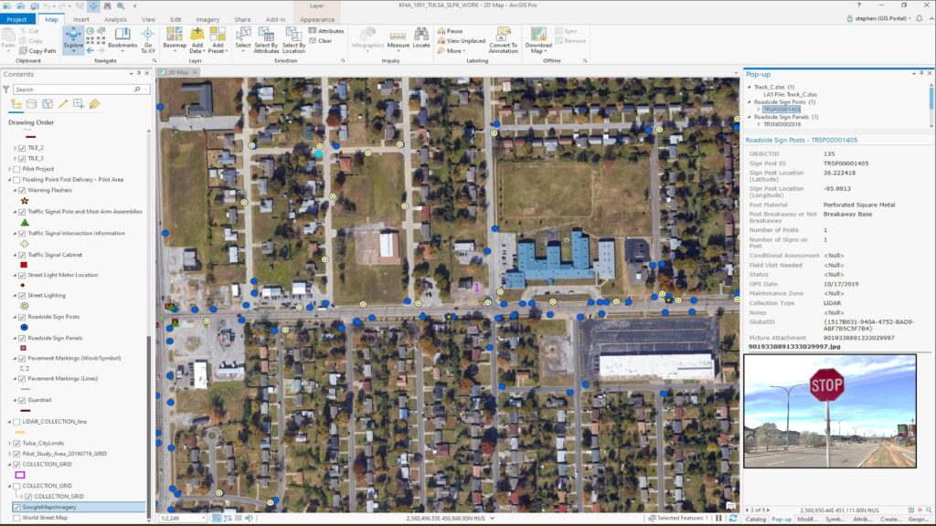
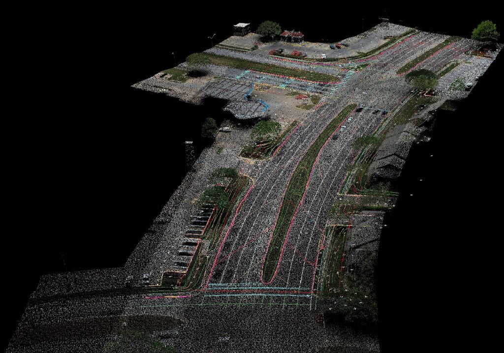
Tulsa Asset Inventory

G&AI acquired and processed 2,064 linear miles for an asset inventory within the City of Tulsa, OK city limits. The processed and classified point cloud and simultaneously collected 360° high-definition imagery were used to performed feature extraction of city assets including, streetlights, guardrails, MUTCD signs, traffic signals, traffic signal cabinets, and school zone flashers. All assets were collected and placed in a 3D ESRI geodatabase.

Jack County Switch 138 kV Line- Substation

G&AI provided GPS control survey, established horizontal and vertical control/ aerial target points utilizing RTK/GPS methodology along the alignment. Acquired 400ft width of LiDAR XYZ data for approximately 1,500 LF of transmission line corridor, including proposed bypass area.  Feature-coded PLS CADD data for 200-ft width of the 400-ft corridor (+/- 6.5 acres).  Established ground control and accuracy verification. Staked 3 proposed structures. G&AI also provided Drone LiDAR as-built survey per Oncor specifications. 

Roanoke Switch - Euless Switch 138 kV Line

G&AI provided GPS control survey, established horizontal and vertical control/ aerial target points utilizing RTK/GPS methodology. G&AI provided Drone and Ground-Based LiDAR/Video/ Photography, which Required 400ft width of LiDAR XYZ data for approximately 1,800 feet. Feature-coded PLS CADD data for 200 ft width of the 400 ft corridor. Provided ROW video and oblique structure photography.  G&AI also provided ROW Survey/staking, Geotech Staking, and construction structure staking. Staked the existing ROW edge for vegetation management limits. Staked Locations requested for soil borings along the transmission line ROW and staked 3 proposed structures. As well as provided Drone LiDAR as-built survey in accordance with Oncor’s specifications. 

Intersection Improvements at S. Hulen Street at Oakmont Boulevard

G&AI provided a topographic/design survey for the Intersection Improvements at S. Hulen Street at Oakmont Boulevard.  The survey included but was not limited to locating buildings, water valves, water vaults, top and toe of slopes, drainage ditches, fences, trees 6″ and larger, landscaped areas, miscellaneous concrete, electrical features, signs, utility markers, asphalt paving, concrete paving, curb and gutter, storm water and waste water manholes and drainage structures with flow lines and pipe sizes. G&AI also provided research on all adjacent properties to the project and obtained copies of all deeds, plats, and easements. As well as Prepare a deed sketch of the existing right-of-way and adjacent properties to the project site.

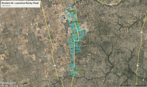
SL East Stiles Sub, SL Einstein, and SL East Stiles (3 in 1 project)

G&AI provided survey services for three transmission line rebuilds, totaling 24.7 miles, all part of the same line. The segments were SL East Stiles Sub – St. Lawrence Sub 138 kV Line (13 miles), SL Einstein- St. Lawrence 138 kV Line (4.6 miles), and SL East Stiles Rocky Road 138 kV Line (7.1 miles). Services included GPS control, ownership deed sketch, ROW survey, substation survey, crossing survey, overhead utility survey, design survey, easement sketch and descriptions, geotech survey, ROW staking, and construction structure staking. Utilizing RTK/GPS, G&AI established horizontal and vertical control, providing property boundary maps for Oncor’s proposed transmission right of way. G&AI located existing railroads, state and county roads. Overhead features were surveyed within 50 feet of the centerline. Supplementary topographic surveys addressed conflicts at proposed structure locations and major road crossings. Easement sketches and descriptions were provided for temporary construction and access easements. G&AI also staked  soil boring locations, existing ROW edges for vegetation management, and proposed structures along the three transmission lines.

DFW D West - Euless 138 kV: Cut-In to DFW Mid Cities Sub(2 Projects in 1)

G&AI provided survey services for the DFW D West – Euless 138 kV project, encompassing substation design, topography, and transmission line cut-in at DFW Airport. Using RTK/GPS, horizontal and vertical control was established, considering existing railroads, state, county, and general roads. Crossing survey was provided when transmission lines crossed railroads or highways. The survey covered overhead features like poles, lights, and billboards along proposed and existing transmission lines. Topographic surveys identified conflicts with proposed structures and major road crossings. G&AI staked locations for soil borings, vegetation management limits, and station pad corners, with convenient offsets. Fence corners and iron rods were set with reference caps. Deliverables included an exhibit with meets and bounds description for the proposed substation lease site, meeting Oncor construction requirements.

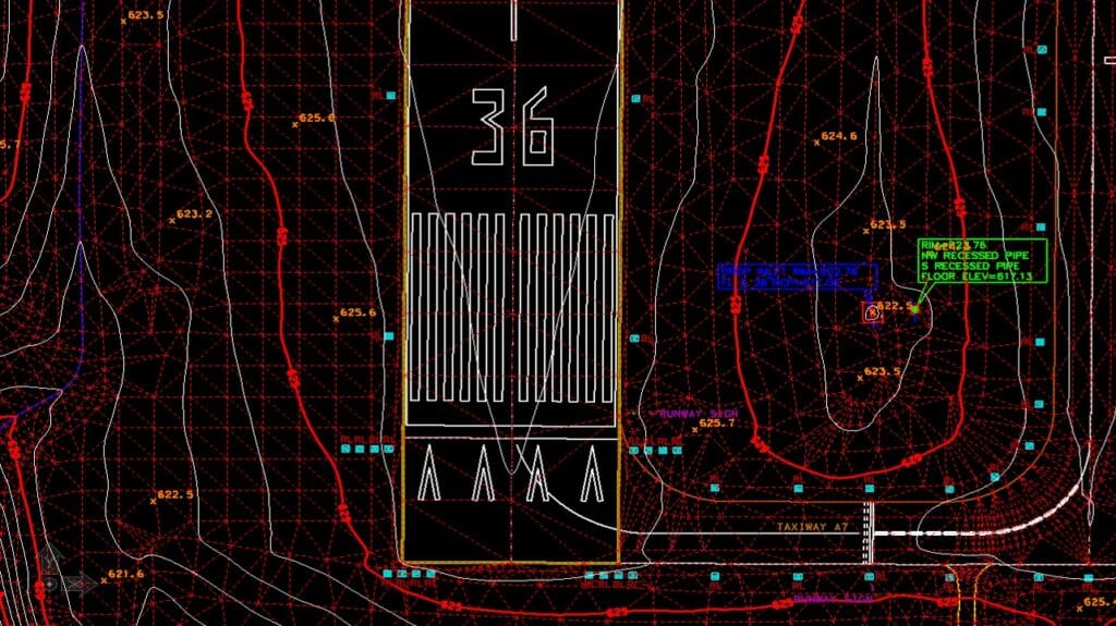
14R 32K Taxiway Improvement

G&AI acquired mobile LiDAR data for airport taxiways on Randolph Airforce Base in San Antonio, TEXAS.  2D planimetrics and 3D DTM were extracted from the processed and classified mobile LiDAR data.  The LiDAR data met TexasDOT specifications of 0.05-ft. vertical RMSE on hard surfaces.  Deliverables included processed and classified LiDAR in .LAS format, georeferenced imagery in JPEG format, 2D planimetrics in AutoCAD format, 3D DTM in AutoCAD format, and TIN and DAT files in GeoPak format.

Our team is happy to answer your questions. Contact us and we’ll be in touch as soon as possible.

Scroll to Top